Targeting a $3 Billion Annual Market, SoundPix® is the Industry’s First Real Time, 3D Seafloor Mapping Solution Using Synthetic Aperture Sonar Technology
ST. JOHN’S, NEWFOUNDLAND – DECEMBER 02, 2015—Kraken Sonar Inc. (“Kraken”) (TSX-V: PNG) announced today that its wholly-owned subsidiary, Kraken Sonar Systems Inc. has released SoundPix® – an innovative solution for next generation seabed mapping.
“Seafloor mapping is one of the oldest professions known to humankind,” said Karl Kenny, President and CEO of Kraken. “For thousands of years, mariners have been measuring the depths under their vessels. Today’s ocean surveying market is valued at over US$3 billion per year. Kraken’s customers and prospects have asked for a high resolution seabed mapping solution that leverages our Synthetic Aperture Sonar (SAS) technology. With SoundPix®, we’ve given it to them – hydrographic surveyors can now increase the quantity of seafloor data, significantly improve data quality and lower data acquisition costs – all in real time. We are extremely excited by the market potential for SoundPix®.”
ABOUT SOUNDPIX®
SoundPix® has been designed to work with Autonomous Underwater Vehicles (AUVs), Unmanned Surface Vehicles (USVs) and conventional survey launches. The solution tightly integrates Kraken’s real-time Synthetic Aperture Sonar signal processing with the data processing and mapping application, CARIS Onboard™ developed by CARIS of Fredericton, New Brunswick. SoundPix® is the world’s first Synthetic Aperture Sonar solution to enable near real time, ultra high resolution imaging and 3D mapping of the seafloor. The development of this new technology is expected to revolutionize the way in which bathymetry and imagery data is processed.

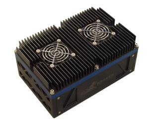
Kraken’s SoundPix® Signal Processor
Today, governments, navies, telecom companies, offshore energy corporations and scientific institutions map the seafloor for many applications. Market research analysts, Douglas Westwood, estimate that the global ocean survey industry is valued at over US$3 billion per year, with hydrographic charting as the largest sector.
The costs involved with seabed mapping are large and are dominated by the expense of survey vessel time, equipment and personnel. As such, any improvement in the planning and execution of seabed mapping; improvement in the quality of the resulting data and reduction in survey costs are of significant interest to the maritime industry.
With technology constantly moving forward, AUVs are now expanding into the mainstream with the ability to complete a wider variety of missions. AUVs face a unique challenge that other unmanned vehicles do not – the ocean. This challenging and harsh environment – in which high pressure can often be present – means that AUVs need to be largely autonomous, able to withstand the rigors of the deep sea environment and be among the most mission diverse vehicles ever designed.
One of the emerging AUV applications is hydrographic surveying. While traditional hydrographic survey (i.e. creating nautical charts) has been carried out using surface based systems, an increasing interest is now being shown toward the use of AUVs for the same purpose. The major drivers are the versatility and multi-disciplinary capability of the AUVs, the stability of the platform and the resulting high quality high-resolution data, the small crew size needed for operations, the ability to carry out missions fully autonomously and the significantly lower cost compared to conventional survey methods.
Hydrographic survey workflow using an AUV requires that the survey data gets relayed back to a central location where high-performance computing systems perform back-end data processing. Then, a survey analyst creates a digital terrain model from the processed sounding data. The delay in this workflow is several hours, or even days, depending on the duration of the AUV mission. Moving processing to the underwater platform – near the sonar sensor – is a similar processing model, but performed on the data in real time without the bottleneck of post mission analysis and data processing. This workflow is much more optimized and achieves near real-time response.
“We certainly expect customers will want to increase their sensor processing capability in order to analyze data locally, which will allow them to make real-time decisions. This will drive the demand for more payload capability, and those decisions may result in additional requirements for other capabilities such as automated target detection and determining target characteristics from the data. What we expect to see in the future is in-stride, autonomous data processing and then passing along the processed information directly to the operator,” said Mr. Kenny. “Putting more of the processing onboard the AUV and generating seabed images, maps, 3D digital terrain models and target data in near real time are really the path to the future of seabed surveys. Reducing, or in some cases, eliminating the need for post-processing of survey data saves significant amounts of time and money and leads to very effective in-situ decision making.”
With SoundPix® workflow, Kraken’s Synthetic Aperture Sonar signal processor outputs processed sonar data in real-time to an embedded version of CARIS Onboard™. The software then automatically converts data as it becomes available and applies a range of pre-determined corrections to generate a terrain model or mosaic. This allows for early visualization of seafloor characteristics and supports an environment of improved efficiency. By the time the survey platform has completed its mission a fully geo-referenced and processed dataset is available for final quality control and incorporation into information products. The system is a force multiplier allowing multiple datasets to be processed quickly and consistently.
Pricing and Availability
SoundPix® is now commercially available, and is priced at US$97,500. This includes the Real Time SAS processing hardware and software solution, as well as a bundled version of CARIS Onboard. The integrated solution is the result of a recently established Original Equipment Manufacturer (OEM) License Agreement enabling CARIS Onboard™ to be delivered with Kraken systems. The agreement outlines the collaboration between the two companies, which have mutual interests to provide the ocean survey industry with a solution to reduce the product creation timeline for seabed mapping using Synthetic Aperture Sonar.
“As our knowledge of the seafloor expands through technologies like Synthetic Aperture Sonar and through the increased use of autonomous survey platforms, it has become critical to introduce automation in the data processing workflow to keep up with the ever increasing volumes of data”, said Andrew Hoggarth, Chief Business Development Officer at CARIS. “The SoundPix® solution is a great fit for our new real-time processing software CARIS Onboard and we are proud to be part of this exciting solution through the establishment of the OEM agreement and ongoing technical collaboration.”
Synthetic Aperture Sonar Technology for Hydrographic Surveys
While conventional sonars are commonly used for seafloor imaging and bathymetry, they suffer from some basic limitations. Firstly, the imaging resolution, or the system’s ability to distinguish closely spaced objects, is not constant but degrades with range. In Synthetic Aperture Sonar, these limitations are overcome by using the sonar platform’s trajectory. The forward motion of the sonar is used to synthesize an array that is much longer than its physical length by combining multiple pings in software rather than adding more hardware as a way to gain higher resolutions.
SAS uses sophisticated signal processing techniques to compare the multiple observations of the same area of seafloor. The image resolution of the seabed is significantly increased – often by an order of magnitude – compared to conventional sidescan sonar. In essence, the resolution becomes independent of range and of frequency. SAS systems can achieve imagery and bathymetry resolution of a few centimeters even in very deep waters.
While SAS has been around for over a decade, military applications such as naval mine countermeasures have been its major development driver. However, SAS is a multi-use technology with great potential for offshore oil and gas surveying, hydrographic surveys, underwater archaeology, benthic habitat mapping and deep sea mining.
The viability of SAS as a high resolution survey sensor seems a logical progression for the industry with the additional benefits of increased data quality, better resolution and a pathway to a deliverable of more integrated data fusion surveys.
In addition to reflectivity images, SAS can produce highly detailed topographic maps of the seafloor by detecting the angle of arrival of seabed echoes coming from a given range bin. In a configuration known as Interferometric SAS (INSAS), two vertically separated arrays produce bathymetric maps that are exactly co-registered with the corresponding SAS images. This combination of synthetic aperture processing and interferometry solves the problems of limited resolution and coverage rates encountered with conventional swath bathymetric sonars and multibeam echo sounders. When the InSAS bathymetric resolution approaches that of the corresponding SAS image, it becomes possible to overlay the reflectivity and topography to create a true 3D picture of objects on the seabed.
The use of INSAS systems – such as the AquaPix system produced by Kraken Sonar Inc. – is a promising tool for achieving these objectives in both very shallow water and deep water environments. AquaPix® produces real-time, high resolution, three dimensional (3D) digital terrain models of the seafloor with bathymetric resolution as fine as 5cm x 5cm and simultaneous co-registered imagery resolution as fine as 3cm x 3cm.
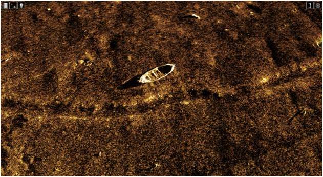
With high resolution INSAS it is possible to use image fusion techniques, such as those provided by CARIS solutions, to combine the bathymetric data with the reflectivity data to create a true 3D representation of objects on the seabed. The ability to generate centimetre-scale resolution in all three dimensions has the potential to provide significant improvements in the detection, classification and identification of small seabed objects.

CARIS 3D View of INSAS imagery draped over co-registered bathymetry
ABOUT KRAKEN SONAR INC.
Kraken Sonar Inc. (TSX.V:PNG) is an industrial technology company, founded in 2012, that is dedicated to the production and sale of software-centric Synthetic Aperture Sonar (SAS) sensors and systems. The Company’s products are sold to leading defence contractors, commercial survey companies and research institutions for producing real-time, ultra-high resolution imagery and bathymetry of the seabed. For more information, please visit www.krakensonar.com.
Neither the TSX Venture Exchange Inc. nor its Regulation Services Provide (as that term is defined in the policies of the TSX Venture Exchange) accepts responsibility for the adequacy or accuracy of this release.

